Index >> Graphic Apps >> Editors >> RoboGEO
Report SpywareRoboGEO 6.3.2

 Click to enlarge screenshot
Software Description:
RoboGEO - Geocode digital photos and export to Google Earth, SHP, DXF, Flickr, and more.
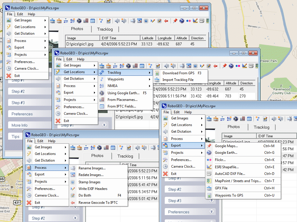
Geocode digital images with latitude, longitude, altitude, and direction information. RoboGEO stamps this information onto the images or writes it to the EXIF, allowing you to permanently geocode and link your photos to the GPS coordinates. All writing to the EXIF and IPTC headers is lossless and all of the existing comments (including the MakerNote and the Adobe XMP metadata) are preserved. Includes a Picasa-style geotagger for Google Earth. Create web pages that use Google Maps, export KML or KMZ files to Google Earth, upload geotagged photos to Flickr, export ESRI SHP shapefiles, export to MapPoint, or export DXF files to AutoCAD or IntelliCAD. Show the photo direction on maps and calculate it from the GPS tracklog. Merge EXIF or IPTC tags into the image titles and descriptions. Record dictation using any modern digital voice recorder and automatically associate audio with the photos. Rotate or redate images based on the EXIF info. Export GPX files. Edit the EXIF times. Lookup altitudes knowing only lat/lon. Photo locations can be projected to a new location in either ground or airplane mode. Free EXIF/IPTC viewer. Geocode any type of JPG, PNG, BMP, TIF, DNG, NEF, CR2, MRW, ERF, RAF, ORF, PEF, ARW SR2, SRW, RW2, RAW, RWL, and MEF. Directly supports Garmin GPS units (USB or COM), but no GPS is required. Geocode images from a GPS tracklog, KML or KMZ files, NMEA sentences, waypoints, known place names OziExploer PLT files, or TCX files. Import GPX files for interfacing with other GPSs like Magellan and Trimble. Import shapefiles. Rename images per the EXIF data. IPTC editor. UTM and MGRS support. Use any digital camera. Internationally aware. Very easy to use. Nice user interface. Can be fully automated from the command line. Perfect tool for aerial photography, land surveyors, engineers, insurance claim adjusters or anyone who needs to collect field data for integration into a GIS system. Affordable. Free lifetime upgrades. Extensive documentation.
What's New: Added Google Earth polygon file support and the ability to export HTML and enhanced the user-interface
Feature List:
- Create web pages that use Google Maps, export KML or KMZ files to Google Earth, upload geotagged photos to Flickr, export ESRI SHP shapefiles, export to MapPoint, or export DXF files to AutoCAD or IntelliCAD
- Show the photo direction on maps and calculate it from the GPS tracklog
- Automatically merge EXIF or IPTC tags into the image titles and descriptions
- Record dictation using any modern digital voice recorder and automatically associate audio with the photos
- Rotate or redate images based on the EXIF info
- Export GPX files
- Edit the EXIF times
- Photo locations can be projected to a new location in either ground or airplane mode
- Free EXIF/IPTC viewer
- Geocode any type of JPG, PNG, BMP, TIF, Adobe DNG file, Canon CR2 or CRW, Minolta MRW, Olympus ORF, or Epson ERF file
- Directly supports Garmin GPS units (USB or COM), but no GPS is required
- Georeference images from a GPS tracklog, NMEA sentences or waypoints
- Import GPX files for interfacing with other GPS makes and models like Magellan, Lowrance or Trimble
- Supports DNR Garmin
- Includes an image renaming utility that renames images based on the EXIF data
- Works with any modern digital camera
- Internationally aware. Very easy to use. Nice user interface
- Perfect tool for aerial photography, land surveyors, engineers, insurance claim adjusters or anyone who needs to collect field data for integration into a GIS system
100% Clean:
 RoboGEO 6.3.2 is 100% clean
This download (rgeo.msi) was tested thoroughly and was found 100% clean. Click "Report Spyware" link on the top if you found this software contains any form of malware, including but not limited to: spyware, viruses, trojans and backdoors.
Related Software:
- ASCII Art Generator 3.2.4.6 - Convert pictures into amazing colorful and readable text quickly and easily
- Colour Studio 2.0 - 5 plug-in filters for use with Adobe Photoshop or compatible host applications
- AKVIS Retoucher 6.0 - AKVIS Retoucher is an efficient software for photo restoration and retouching.
- FotoBatch 5.1.3.0818 - It will allow you to convert and processing image files using scripts.
- Project5 Photocut Processor 1.0.10.1005 - Bitmap tracer (raster to vector), realistic photo effect in vinyl decals
- FunPhotor 6.2003 - Fun Photo Creator - Put Your Face on Fantasy & Fun Photo!
- PixBuilder Studio 1.31 - PixBuilder Studio is graphic software for photo editing and images manipulation.
- AKVIS Stamp 3.0 - AKVIS Stamp - Image Healing Tool for seamless defects removal and object cloning
- RPE Photo 3.0 - Easy Digital Photo Resizing, Printing and Enhancement. Learn in Minutes!
- Able Fax Tif View 3.17.2.20 - Multi-page tif, pdf, eps, ai, dcx viewer, editor and converter.
top 10 most downloaded
recommended software
-
- 1AVCenter
- With 1AVCenter you can record your entire screen or part of it directly to AVI or WMV, capture screenshots in JPG, share your screen over the internet...
-
- IconEdit2
- Create and edit icon files for Windows, iPhone, iPad, Apple Watch, and Android with professional yet easy-to-use Icon Editor. IconEdit2 has full suppo...