Index >> Graphic Apps >> CAD >> Mapwel
Report SpywareMapwel Build-8.9-2012

 Click to enlarge screenshot
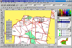
Software Description:
Mapwel - Software for creation of custom GPS maps compatible with Garmin GPS units.
All-in-one software for creation of custom GPS maps compatible with Garmin GPS units. Mapwel supports routing, ESRI shapefiles, OpenStreetMap OSM, Google Earth KML and KMZ, cGPSmapper MP and GPX files. Mapwel custom GPS mapping capability and user icons editor are often used in forestry, electrical engineering, geology and geodesy. Creation of a GPS map involves georeference of raster images, drawing of the vector map, import of data from various file formats and online sources, conversion of the map data into the native format of the GPS and upload of that data into the GPS. Mapwel is the only available mapping software compatible with Garmin GPS units that allows the user to do the all above steps with a single software tool. Mapwel uses its own map compiler.
What's New: OSM files splitter.
Limitations: Demo truncates maps unless the map is uploaded to safe test area near N0.0,W0.0
100% Clean:
 Mapwel Build-8.9-2012 is 100% clean
This download (mapwlstp.zip) was tested thoroughly and was found 100% clean. Click "Report Spyware" link on the top if you found this software contains any form of malware, including but not limited to: spyware, viruses, trojans and backdoors.
Related Software:
- ABViewer 9.1 - CAD DWG DXF HPGL TIFF CGM SVG WMF STEP IGES STL SAT viewer, editor and converter
- Visual Drawing Maker 1.13 - Convert CAD files into self viewing executable (*.exe) files.
- MITCalc3D for SolidWorks 1.61 - Mechanical, Industrial and Technical Calculations for SolidWorks
- AutoQ3D CAD 5.10 - Full CAD application that let you make a lot of things in 2D & 3D
- progeCAD Professional AutoCAD Clone 2011.2.0.9 - progeCAD AutoCAD DWG Clone, 1/10th the cost, no learning curve for AutoCAD users
- DWF to DWG Converter 2007 2010 - Instantly convert DWF files to AutoCAD DWG and DXF files.
- AutoDWG Attribute Extractor 2.8 - AutoDWG Attribute Extractor, extract attribute information
- Maze Creator PRO 1.70 - Create random customized mazes with solution; add pictures, text, change shape
- ACAD DWG Viewer Pro 3 - DWGSee, a lite and fast DWG/DXF/DWF Viewer, batch print DWG/DXF/DWF files.
- VaryTable 2.1.0005 - Converts any selected text array in a CAD drawing into spread sheet cell table
top 10 most downloaded
recommended software
-
- 1AVCenter
- With 1AVCenter you can record your entire screen or part of it directly to AVI or WMV, capture screenshots in JPG, share your screen over the internet...
-
- IconEdit2
- Create and edit icon files for Windows, iPhone, iPad, Apple Watch, and Android with professional yet easy-to-use Icon Editor. IconEdit2 has full suppo...