Index >> Graphic Apps >> Editors >> Canvas GIS Mapping Edition
Report SpywareCanvas GIS Mapping Edition 9.0.4

 Click to enlarge screenshot
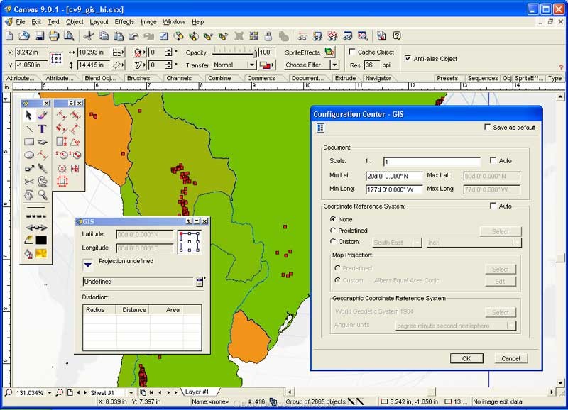
Software Description:
Canvas GIS Mapping Edition - GIS Mapping support plus illustration, image editing, & presentation features.
The CANVAS 9 GIS Mapping Edition adds native support for Geographic Information System (GIS) data to Canvas. You can take measurements in geographic coordinates, import industry standard SHAPE and GeoTIFF files into unlimited numbers of automatically aligned overlapping layers and choose among the following options:
2,104 Coordinate Reference Systems
67 Operation Methods (like Mercator, Albers Conic Equal Area…)
1,052 Map Projections
302 Geodetic Datums
21 Angular units
45 Length units
The CANVAS 9 GIS Mapping Edition bridges the gap between dedicated GIS analysis software and generic "DTP" software. For many applications CANVAS 9 GIS Mapping Edition can now replace programs costing thousands. For the rest, CANVAS 9 GIS Mapping Edition is now the preferred "last mile" publishing companion to dedicated GIS analysis software.
What's New: GIS specific features are now available via a top-level menu. Importing SHP files streamlined & Improved
Limitations: 15 Days Trial
100% Clean:
 Canvas GIS Mapping Edition 9.0.4 is 100% clean
This download (canvas.exe) was tested thoroughly and was found 100% clean. Click "Report Spyware" link on the top if you found this software contains any form of malware, including but not limited to: spyware, viruses, trojans and backdoors.
Related Software:
- ACD FotoCanvas 3.0.3 - Fix and enhance photos with this easy and affordable product. An award-winner.
- Stitcher EZ 1.0 - Make panoramas, posters, virtual tours of your photos easily. Plug-in to ACDSee.
- Stitcher 3.5 - Create panoramas for print, web, film and 3D. This plug-in for ACDSee by REALVIZ
- ACDSee Plugin - RoboEnhancer 1.0 - RoboEnhancer - the script software for batch processing digital image files
- ACDSee Plugin - RealOptimizer 1.0 - Reduce the frustration of image compression work with this optimization software
- PicaView 2.0 - The simple, effective, right click image viewer "add-on" for Windows explorer.
- Morpheus Photo Animator 1.85 - Graphics software for transforming photos with morphing and warping effects.
- ImageFox 2.0 - View images, videos and sound files in most Windows Open/Save_as dialog boxes.
- FotoVac 1.0 - FotoVac is a mass image downloader that downloads pictures from usenet newsgroup
- ACD FotoAngelo 2.0 - Make and share multimedia slide shows and screen savers with ease.
top 10 most downloaded
recommended software
-
- 1AVCenter
- With 1AVCenter you can record your entire screen or part of it directly to AVI or WMV, capture screenshots in JPG, share your screen over the internet...
-
- IconEdit2
- Create and edit icon files for Windows, iPhone, iPad, Apple Watch, and Android with professional yet easy-to-use Icon Editor. IconEdit2 has full suppo...