Index >> Business >> Databases & Tools >> GIS ObjectLand
Report SpywareGIS ObjectLand 2.7.7

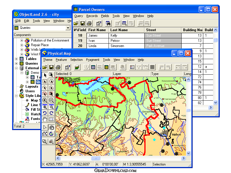 Click to enlarge screenshot
Software Description:
GIS ObjectLand is a universal Geographic Information System for Windows
GIS ObjectLand is a universal Geographic Information System for Windows.
Key features:
- creation of vector-raster maps with arbitrary structure of layers and feature types in an internal ObjectLand database or in following DBMSs - MS SQL Server, Oracle, DB2, MySQL, Interbase/Firebird, PostgreSQL, MS Access;
- creation of themes. Theme is a user presentation of a map;
- control of displaying features depending on the chosen scale;
- spatial data input and editing by assigning feature coordinates and also by interactive drawing with mouse or digitizer;
- sewing of separate pages of an imported map into one unified continuous map;
- copying, merging, and moving maps, layers, and feature types between different geoinformation databases;
- creation of tables of arbitrary structure;
- creation of queries. Query is a user presentation of table built by setting search and sorting conditions, joining tables, calculations and using reference tables;
- copying, merging, and moving tables and queries between different geoinformation databases;
- setting arbitrary links between spatial and table information;
- getting information about the feature selected on the map;
- searching for features on the map by linked records;
- creation of filters. Filter is conditions of feature visualization depending on spatial properties of features and linked table data;
- creation of layouts. Layout is an output form combining spatial, table information and presentation elements;
- import and export of table and spatial information for widespread data formats;
- support of style libraries containing fonts, map symbols, line styles, hatches and fill styles;
- style editors for displaying styles;
- setting for users the access permissions to components;
- multiuser data editing;
- using and editing tables of external database (via ODBC) as linked tables;
- providing automation COM interfaces for user applications.
Limitations: Noncommercial version
Feature List:
- creation of vector-raster maps with arbitrary structure of layers and feature types
- creation of themes. Theme is a user presentation of a map
- control of displaying features depending on the chosen scale
- spatial data input and editing by assigning feature coordinates and also by interactive drawing with mouse or digitizer
- sewing of separate pages of an imported map into one unified continuous map
- copying, merging, and moving maps, layers, and feature types between different geoinformation databases
- creation of tables of arbitrary structure
- creation of queries. Query is a user presentation of table built by setting search and sorting conditions, joining tables, calculations and using reference tables
- copying, merging, and moving tables and queries between different geoinformation databases
- setting arbitrary links between spatial and table information
- getting information about the feature selected on the map
- searching for features on the map by linked records
- creation of filters. Filter is conditions of feature visualization depending on spatial properties of features and linked table data
- creation of layouts. Layout is an output form combining spatial, table information and presentation elements
- import and export of table and spatial information for widespread data formats
- support of style libraries containing fonts, map symbols, line styles, hatches and fill styles
- style editors for displaying styles
- setting for users the access permissions to components
- multiuser data editing
- using and editing tables of external database (via ODBC) as linked tables
- providing automation COM interfaces for user applications
100% Clean:
 GIS ObjectLand 2.7.7 is 100% clean
This download (objlandnc.exe) was tested thoroughly and was found 100% clean. Click "Report Spyware" link on the top if you found this software contains any form of malware, including but not limited to: spyware, viruses, trojans and backdoors.
Related Software:
- SQLite Analyzer 3.0.4.27 - Process SQLite databases visually with SQLite Analyzer! Free trial!
- Full Convert Professional SQL Server Ed. 1.3 - Full Convert provides powerful and comfortable way to convert databases.
- Full Convert Standard SQL Server Edition 1.3 - Full Convert provides powerful and comfortable way to convert databases.
- Full Convert Standard MySQL Edition 1.3 - Full Convert provides powerful and comfortable way to convert databases.
- Full Convert Professional MySQL Edition 1.3 - Full Convert provides powerful and comfortable way to convert databases.
- Mobile Database Viewer(Access,xls,Oracle)for UIQ 1.1 - View Access,Foxpro,dBase,Excel and any ODBC enable Database on UIQ mobile phone.
- Cornolius Database Application 1.4.300 - A secure multi-user database creator and manager for individuals and businesses!
- DBConvert for Access & MySQL 6.0.0 - Bi-directional db conversion tool for MS Access and MySQL databases
- SQL Data Examiner 2010 R2 4.1.0 - SQL compare and synchronization for SQL Server, Oracle, MySQL, SQL Azure, Acces.
- DBF-to-MySQL 4.3 - DBF-to-MySQL is a program to migrate FoxPro/DBase databases to MySQL server.
top 10 most downloaded
recommended software
-
- A VIP Organizer
- VIP Organizer is a time and task management software which uses To Do List method to help you get through more work spending less time. It increases y...

-
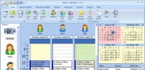
- Salon Calendar
- Salon Calendar is a software tool designed specially for hair salons, beauty, manicure or aesthetic shops, tanning salons, fitness studios, wedding sa...